Geolocate

Italy topographic map

Click on the map to display elevation.

About this map

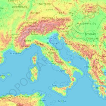
Name: Italy topographic map, elevation, terrain.

Location: Italy (35.13843 5.17430 50.13843 20.17430)

Average elevation: 335 m

Minimum elevation: -5 m

Maximum elevation: 4,188 m

Other topographic maps

Click on a map to view its topography, its elevation and its terrain.

Seiser Alm-Gruppe - Gruppo Mont de Sëuc - Gruppo dell'Alpe di Siusi

Italy > Trentino – Alto Adige/Südtirol > South Tyrol > Kastelruth - Castelrotto

Seiser Alm (Italian: Alpe di Siusi, Ladin: Mont Sëuc) is a Dolomite plateau and the largest high-elevation Alpine meadow (German: Alm) in Europe. Located in Italy's South Tyrol province in the Dolomites mountain range, it is a major tourist attraction, notably for skiing and hiking.

Average elevation: 1,466 m

Roma Capitale

Italy > Lazio

Average elevation: 308 m

Penne

Italy > Abruzzo > Pescara

Average elevation: 294 m

Marostica

Italy > Veneto > Vicenza

Average elevation: 230 m

Cùllieri/Cuglieri

Italy > Sardinia > Aristanis/Oristano

Average elevation: 382 m

Sauze d'Oulx

Italy > Piedmont > Torino

Average elevation: 1,714 m

Argusto

Italy > Calabria > Catanzaro

Average elevation: 470 m

Lake Como

Italy > Lombardy > Como

Lake Como weather is humid subtropical (Cfa in the Köppen climate classification). In winter, the lake helps to maintain a higher temperature in the surrounding region. Average daily temperatures range from ~3.7 °C (39 °F) in January to 23.4 °C (74 °F) in July, according to historical weather data from…

Average elevation: 885 m

Palestrina

Italy > Lazio > Roma Capitale

Average elevation: 404 m

Borgetto

Italy > Sicily > Palermo

Average elevation: 429 m

Caronia

Italy > Sicily > Messina

The climate is Hot Summer Mediterranean. The station’s elevation is 302 meters above sea level.

Average elevation: 580 m

Savignano Irpino

Italy > Campania > Avellino

Average elevation: 620 m

Termoli

Italy > Molise > Campobasso

Average elevation: 43 m

Tufo

Italy > Campania > Avellino

Average elevation: 399 m

Rionero in Vulture

Italy > Basilicata > Potenza

Average elevation: 594 m

Corato

Italy > Apulia > Bari

Average elevation: 310 m

Quartiere Gallaratese

Italy > Lombardy > Milan > Milan

Average elevation: 137 m

Alfedena

Italy > Abruzzo > L'Aquila

Average elevation: 1,101 m

Riano

Italy > Lazio > Roma Capitale

Average elevation: 115 m

Grado

Italy > Friuli – Venezia Giulia > Gorizia

Average elevation: 0 m

Alto

Italy > Piedmont > Cuneo

Average elevation: 776 m

Ritten - Renon

Italy > Trentino – Alto Adige/Südtirol > South Tyrol

The 111-square-kilometre (43 sq mi) community is named after the high plateau, elevation 1,100 to 1,400 metres (3,600 to 4,600 ft), the Ritten or the Renon, on which most of the villages are located. The plateau forms the southeast tip of the Sarntal Alps mountain range and is located between, and on average…

Average elevation: 1,123 m

Borca di Cadore

Italy > Veneto > Belluno

Average elevation: 1,589 m

Tevere

Italy > Lazio > Roma Capitale > Fiumicino

Average elevation: 2 m

Su Masu/Elmas

Italy > Sardinia > Casteddu/Cagliari

Average elevation: 8 m

Monte Isola

Italy > Lombardy > Brescia

The municipality covers a total area of 12.8 square kilometres (4.9 sq mi); the main island, Monte Isola, with an area of 4.5 square kilometres (1.7 sq mi) ranks as the largest lake island not only in Italy, but also in South and Central Europe, but is dwarfed by the large lake islands in Northern Europe. The…

Average elevation: 220 m

Lazise

Italy > Veneto > Verona

Average elevation: 101 m

Piazzatorre

Italy > Lombardy > Bergamo

Average elevation: 1,402 m

Trapani

Italy > Sicily

Average elevation: 92 m

Arcisate

Italy > Lombardy > Varese

Average elevation: 454 m

Sori

Italy > Liguria > Genoa

Average elevation: 328 m

Rosello

Italy > Abruzzo > Chieti

Average elevation: 938 m

Su Tingiosu

Italy > Sardinia > Aristanis/Oristano > Cabras

Average elevation: 8 m

Montebello di Bertona

Italy > Abruzzo > Pescara

Average elevation: 535 m

Fara San Martino

Italy > Abruzzo > Chieti

Average elevation: 933 m

Colle Sannita

Italy > Campania > Benevento

Average elevation: 702 m

Lugo

Italy > Emilia-Romagna > Ravenna

Average elevation: 7 m

Bruno

Italy > Piedmont > Asti

Average elevation: 172 m

Monterado

Italy > Marche > Ancona

Average elevation: 81 m

Montà

Italy > Piedmont > Cuneo

Average elevation: 302 m

Tarano

Italy > Lazio > Rieti

Average elevation: 186 m

Bolano

Italy > Liguria > La Spezia

Average elevation: 161 m

Sutera

Italy > Sicily > Caltanissetta

Average elevation: 324 m

Zoagli

Italy > Liguria > Genoa

Average elevation: 222 m

Castelseprio

Italy > Lombardy > Varese

Average elevation: 307 m

Roncello

Italy > Lombardy > Monza and Brianza

Average elevation: 194 m

Orgiano

Italy > Veneto > Vicenza

Average elevation: 43 m

Chieri

Italy > Piedmont > Torino

Average elevation: 304 m

Ulìana/Oliena

Italy > Sardinia > Nuoro

Average elevation: 426 m

Mansuè

Italy > Veneto > Province of Treviso

Average elevation: 11 m

Lago Riane

Italy > Liguria > Genoa > Santo Stefano d'Aveto

Average elevation: 1,333 m

Montaldo Roero

Italy > Piedmont > Cuneo

Average elevation: 311 m

Bormida

Italy > Liguria > Savona

Bormida is about 20 kilometres (12 mi) west of Savona (as the crow flies) in the upper Val Bormida between the mountain peaks of Settepani, elevation 1,386 metres (4,547 ft), and Ronco di Maglio, elevation 1,108 metres (3,635 ft). The Bormida di Pallare, a tributary of the Bormida di Spigno, flows through its…

Average elevation: 793 m

Sardinia

Italy > Sardinia > Austis

The climate of the island is variable from area to area, due to several factors including the extension in latitude and the elevation. It can be classified in two different macrobioclimates (Mediterranean pluviseasonal oceanic and Temperate oceanic), one macrobioclimatic variant, called Submediterranean, and…

Average elevation: 115 m

Lake Garda

Italy > Lombardy > Brescia

The particularly mild climate favours the growth of some hardy Mediterranean plants, including the olive tree, parasol pine, mediterranean cypress, chinese windmill palm and Canary Island Date Palm. Some hardy citrus trees, such as hardy lemons and satsuma can also be found, which are extremely rare at this…

Average elevation: 571 m

Siena

Italy > Tuscany > Siena

Average elevation: 251 m

Cesarò

Italy > Sicily > Messina

Average elevation: 1,048 m

Lamon

Italy > Veneto > Belluno

Average elevation: 961 m

Torviscosa

Italy > Friuli – Venezia Giulia > Udine

Average elevation: 3 m

Sorano

Italy > Tuscany > Grosseto

Average elevation: 457 m

Ventotene

Italy > Lazio > Latina

Average elevation: 4 m

Chiavari

Italy > Liguria > Genoa

Average elevation: 85 m

Borzonasca

Italy > Liguria > Genoa

Average elevation: 831 m

Neirone

Italy > Liguria > Genoa

Average elevation: 696 m

Muzzano

Italy > Piedmont > Biella

Average elevation: 670 m

Castel del Monte

Italy > Apulia > Andria

Castel del Monte is situated on a small hill close to the monastery of Santa Maria del Monte, at an altitude of 540 metres (1,770 ft). When the castle was built, the region was famously fertile with a plentiful supply of water and lush vegetation. It lies in the comune of Andria, province of…

Average elevation: 453 m

Opi

Italy > Abruzzo > L'Aquila

Average elevation: 1,454 m

Fossa

Italy > Abruzzo > L'Aquila

Average elevation: 649 m

Barisciano

Italy > Abruzzo > L'Aquila

Average elevation: 1,217 m

Duno

Italy > Lombardy > Varese

Average elevation: 665 m

Mirafiori Sud

Italy > Piedmont > Torino > Turin

Average elevation: 245 m

Isola Santa Maria

Italy > Sicily > Trapani > Marsala

Average elevation: 1 m

Molazzana

Italy > Tuscany > Lucca

Average elevation: 519 m

Roncola

Italy > Lombardy > Bergamo

Average elevation: 644 m

Aci Sant'Antonio

Italy > Sicily > Catania

Average elevation: 319 m

Manduria

Italy > Apulia > Taranto

Average elevation: 70 m

Alps

Italy > Lombardy > Bellagio

The altitude and size of the range affects the climate in Europe; in the mountains precipitation levels vary greatly and climatic conditions consist of distinct zones. Wildlife such as ibex live in the higher peaks to elevations of 3,400 m (11,155 ft), and plants such as Edelweiss grow in rocky areas in lower…

Average elevation: 1,284 m

Lake Orta

Italy > Piedmont > Novara > Pettenasco

Average elevation: 649 m

Ustica

Italy > Sicily > Palermo

Average elevation: 30 m

Ortucchio

Italy > Abruzzo > L'Aquila

Average elevation: 827 m

Brenzone sul Garda

Italy > Veneto > Verona

Average elevation: 683 m

Bonassola

Italy > Liguria > La Spezia

Average elevation: 259 m

Furci Siculo

Italy > Sicily > Messina

Average elevation: 299 m

Nogara

Italy > Veneto > Verona

Average elevation: 19 m

Sutri

Italy > Lazio > Viterbo

Average elevation: 363 m

Morgex

Italy > Aosta Valley

Average elevation: 1,818 m

Limbiate

Italy > Lombardy > Monza and Brianza

Average elevation: 195 m

Calalzo di Cadore

Italy > Veneto > Belluno

Average elevation: 1,396 m

Enego

Italy > Veneto > Vicenza

Average elevation: 896 m