
Thank you for supporting this site ❤️
Make a donation
Make a donation
Sintra topographic map
Click on the map to display elevation.
Thank you for supporting this site ❤️
Make a donation
Make a donation
About this map
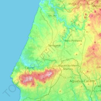
Name: Sintra topographic map, elevation, terrain.
Location: Sintra, Lisbon, Portugal (38.73858 -9.50053 38.93243 -9.22069)
Average elevation: 154 m
Minimum elevation: 0 m
Maximum elevation: 501 m
Thank you for supporting this site ❤️
Make a donation
Make a donation