
Thank you for supporting this site ❤️
Make a donation
Make a donation
Drabo topographic map
Click on the map to display elevation.
Thank you for supporting this site ❤️
Make a donation
Make a donation
About this map
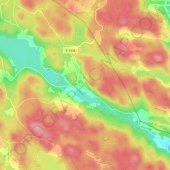
Name: Drabo topographic map, elevation, terrain.
Location: Drabo, Kinda kommun, Östergötland County, Sweden (57.97615 16.00501 58.01615 16.04501)
Average elevation: 149 m
Minimum elevation: 85 m
Maximum elevation: 194 m
Thank you for supporting this site ❤️
Make a donation
Make a donation
Other topographic maps
Click on a map to view its topography, its elevation and its terrain.
Thank you for supporting this site ❤️
Make a donation
Make a donation
Thank you for supporting this site ❤️
Make a donation
Make a donation
Thank you for supporting this site ❤️
Make a donation
Make a donation
Thank you for supporting this site ❤️
Make a donation
Make a donation