
Thank you for supporting this site ❤️
Make a donation
Make a donation
Plumsted Township topographic map
Click on the map to display elevation.
Thank you for supporting this site ❤️
Make a donation
Make a donation
About this map
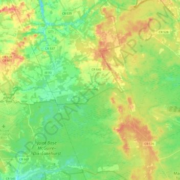
Name: Plumsted Township topographic map, elevation, terrain.
Average elevation: 37 m
Minimum elevation: 14 m
Maximum elevation: 69 m
Thank you for supporting this site ❤️
Make a donation
Make a donation
Other topographic maps
Click on a map to view its topography, its elevation and its terrain.
Cranberry Hill
United States > New Jersey > Ocean County > Lacey Township > Forked River
Average elevation: 10 m
Thank you for supporting this site ❤️
Make a donation
Make a donation
Thank you for supporting this site ❤️
Make a donation
Make a donation
Mystic Islands
United States > New Jersey > Ocean County > Little Egg Harbor Township
Average elevation: 1 m
Thank you for supporting this site ❤️
Make a donation
Make a donation
Thank you for supporting this site ❤️
Make a donation
Make a donation
West Tuckerton Landing
United States > New Jersey > Ocean County > Tuckerton > West Tuckerton Landing
Average elevation: 5 m
Thank you for supporting this site ❤️
Make a donation
Make a donation