
Kohlthal topographic map
Interactive map
Click on the map to display elevation.
About this map
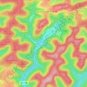
Name: Kohlthal topographic map, elevation, terrain.
Average elevation: 315 m
Minimum elevation: 208 m
Maximum elevation: 409 m
Other topographic maps
Click on a map to view its topography, its elevation and its terrain.
Sapin
France > Grand Est > Bas-Rhin > La Petite-Pierre
Sapin, Chemin Forestier d'Imsthal, La Petite-Pierre, Saverne, Bas-Rhin, Grand Est, France métropolitaine, 67290, France
Average elevation: 309 m