
Make a donation
Stone Mountain topographic map
Click on the map to display elevation.
Make a donation
Stone Mountain
Stone Mountain is the centerpiece of Stone Mountain State Park. It is a dome of exposed granite (specifically a quartz diorite to granodiorite) of Devonian age, which has intruded into the gneiss of the Precambrian Alligator Back Formation. It rises sharply over 600 feet (183 m) above the surrounding terrain. The mountain, which has an elevation of 2,305 feet (706 m) above sea level, is known for its barren sides and distinctive brown-gray color, and can be seen for miles. The mountain offers some of the best rock climbing in North Carolina, and the park's creeks and streams feature excellent brook trout fishing.
Make a donation
About this map
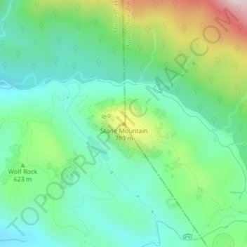
Name: Stone Mountain topographic map, elevation, terrain.
Location: Stone Mountain, Wilkes County, North Carolina, United States (36.39361 -81.04403 36.39371 -81.04393)
Average elevation: 567 m
Minimum elevation: 416 m
Maximum elevation: 927 m
Make a donation
Other topographic maps
Click on a map to view its topography, its elevation and its terrain.
Rendezvous Mountain State Park
United States > North Carolina > Wilkes County
Average elevation: 541 m
Make a donation
Make a donation