
Thank you for supporting this site ❤️
Make a donation
Make a donation
Seronera topographic map
Click on the map to display elevation.
Thank you for supporting this site ❤️
Make a donation
Make a donation
About this map
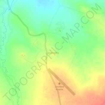
Name: Seronera topographic map, elevation, terrain.
Location: Seronera, Serengeti, Mara Region, Lake Zone, Tanzania (-2.46588 34.79815 -2.42588 34.83815)
Average elevation: 1,515 m
Minimum elevation: 1,488 m
Maximum elevation: 1,545 m
Thank you for supporting this site ❤️
Make a donation
Make a donation
Other topographic maps
Click on a map to view its topography, its elevation and its terrain.
Mara River
The altitudes in the basin range from 2,932 m around the sources in the Mau Escarpment to 1,134 m around Lake Victoria. The amount of precipitation varies according to these altitudes. The Mau Escarpment receives most rainfall with a mean annual rainfall between 1,000 and 1,750 mm. The transboundary middle…
Average elevation: 1,555 m
Thank you for supporting this site ❤️
Make a donation
Make a donation