
Thank you for supporting this site ❤️
Make a donation
Make a donation
Putnam County topographic map
Click on the map to display elevation.
Thank you for supporting this site ❤️
Make a donation
Make a donation
About this map
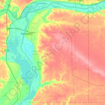
Name: Putnam County topographic map, elevation, terrain.
Location: Putnam County, Illinois, United States (41.10421 -89.46650 41.32191 -89.16215)
Average elevation: 181 m
Minimum elevation: 130 m
Maximum elevation: 236 m
Thank you for supporting this site ❤️
Make a donation
Make a donation
Other topographic maps
Click on a map to view its topography, its elevation and its terrain.
Thank you for supporting this site ❤️
Make a donation
Make a donation
Thank you for supporting this site ❤️
Make a donation
Make a donation
Lake Zurich Highlands
United States > Illinois > Lake Zurich > Lake Zurich Highlands
Average elevation: 261 m
Thank you for supporting this site ❤️
Make a donation
Make a donation