
Make a donation
Zell am See topographic map
Click on the map to display elevation.
Make a donation
Zell am See
Zell am See provides winter skiing on the above Schmittenhöhe mountain. The skiable area is approximately 138 km, including the pistes on the Kitzsteinhorn and Kaprun Maiskogel. The ski pass covers the whole area including transport to and from the glacier which is open most of the year, dependent on snowfall. Zell am See is a low-altitude ski area and snow cover can suffer from higher temperatures, but the glacier has snow cover most of the year.
Make a donation
About this map
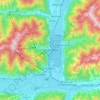
Name: Zell am See topographic map, elevation, terrain.
Location: Zell am See, Bezirk Zell am See, Salzburg, 5700, Austria (47.28200 12.73548 47.36532 12.89996)
Average elevation: 1,118 m
Minimum elevation: 742 m
Maximum elevation: 1,994 m
Make a donation
Other topographic maps
Click on a map to view its topography, its elevation and its terrain.
Königsleiten
Austria > Salzburg > Bezirk Zell am See > Gemeinde Wald im Pinzgau > Königsleiten
Average elevation: 1,703 m