
Thank you for supporting this site ❤️
Make a donation
Make a donation
Highland topographic map
Click on the map to display elevation.
Thank you for supporting this site ❤️
Make a donation
Make a donation
About this map
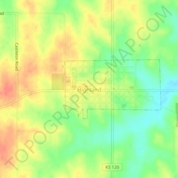
Name: Highland topographic map, elevation, terrain.
Location: Highland, Doniphan County, Kansas, 66035, United States (39.85530 -95.27454 39.86429 -95.25550)
Average elevation: 315 m
Minimum elevation: 288 m
Maximum elevation: 338 m
Thank you for supporting this site ❤️
Make a donation
Make a donation
Other topographic maps
Click on a map to view its topography, its elevation and its terrain.
Highland Elementary School
United States > Kansas > Doniphan County > Highland
Average elevation: 313 m