
Thank you for supporting this site ❤️
Make a donation
Make a donation
Dukuhturi topographic map
Click on the map to display elevation.
Thank you for supporting this site ❤️
Make a donation
Make a donation
About this map
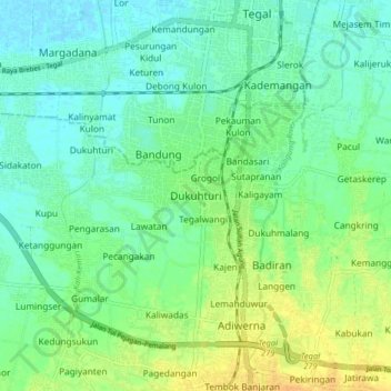
Name: Dukuhturi topographic map, elevation, terrain.
Location: Dukuhturi, Tegal, Central Java, Java, 52124, Indonesia (-6.94469 109.08522 -6.86469 109.16522)
Average elevation: 10 m
Minimum elevation: -2 m
Maximum elevation: 28 m
Thank you for supporting this site ❤️
Make a donation
Make a donation
Other topographic maps
Click on a map to view its topography, its elevation and its terrain.