
Thank you for supporting this site ❤️
Make a donation
Make a donation
Yampil topographic map
Click on the map to display elevation.
Thank you for supporting this site ❤️
Make a donation
Make a donation
Yampil
The city is located along Horyn River, a tributary of the Pripyat, and is part of the Podolsk Plateau [uk], while straddling the border with Lesser Polissia.[uk] Yampol is located in the more elevated part of Khmelnytskyi Oblast, in the Volyn highlands, where the average elevation is 329 meters above sea level.
Thank you for supporting this site ❤️
Make a donation
Make a donation
About this map
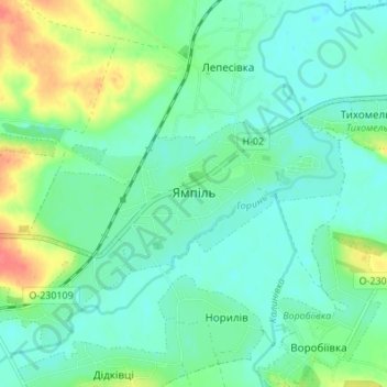
Name: Yampil topographic map, elevation, terrain.
Average elevation: 253 m
Minimum elevation: 238 m
Maximum elevation: 292 m
Thank you for supporting this site ❤️
Make a donation
Make a donation
Other topographic maps
Click on a map to view its topography, its elevation and its terrain.