
Thank you for supporting this site ❤️
Make a donation
Make a donation
Lønstrup topographic map
Click on the map to display elevation.
Thank you for supporting this site ❤️
Make a donation
Make a donation
About this map
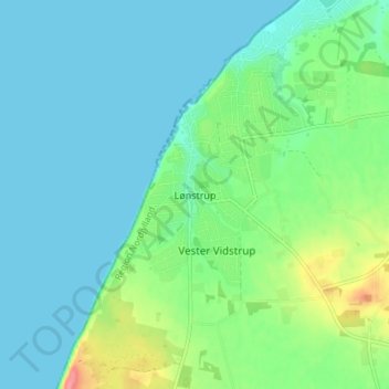
Name: Lønstrup topographic map, elevation, terrain.
Location: Lønstrup, Hjørring Municipality, North Denmark Region, Denmark (57.44844 9.77801 57.48844 9.81801)
Average elevation: 18 m
Minimum elevation: 0 m
Maximum elevation: 76 m
Thank you for supporting this site ❤️
Make a donation
Make a donation
Other topographic maps
Click on a map to view its topography, its elevation and its terrain.
Thank you for supporting this site ❤️
Make a donation
Make a donation
Thank you for supporting this site ❤️
Make a donation
Make a donation
Thank you for supporting this site ❤️
Make a donation
Make a donation