
Thank you for supporting this site ❤️
Make a donation
Make a donation
Myrtle Grove topographic map
Click on the map to display elevation.
Thank you for supporting this site ❤️
Make a donation
Make a donation
About this map
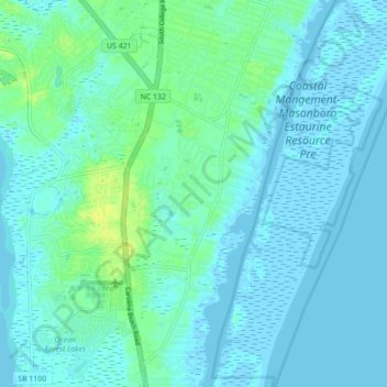
Name: Myrtle Grove topographic map, elevation, terrain.
Average elevation: 4 m
Minimum elevation: -3 m
Maximum elevation: 15 m
Thank you for supporting this site ❤️
Make a donation
Make a donation
Other topographic maps
Click on a map to view its topography, its elevation and its terrain.
Thank you for supporting this site ❤️
Make a donation
Make a donation
Thank you for supporting this site ❤️
Make a donation
Make a donation
College Acres
United States > North Carolina > New Hanover County > Wilmington
Average elevation: 11 m
Lincoln Forest
United States > North Carolina > New Hanover County > Wilmington
Average elevation: 13 m
Carolina Beach
United States > North Carolina > New Hanover County > Carolina Beach
Average elevation: 1 m
Thank you for supporting this site ❤️
Make a donation
Make a donation
Princess Place
United States > North Carolina > New Hanover County > Wilmington
Average elevation: 9 m