
Yeruham topographic map
Click on the map to display elevation.
About this map
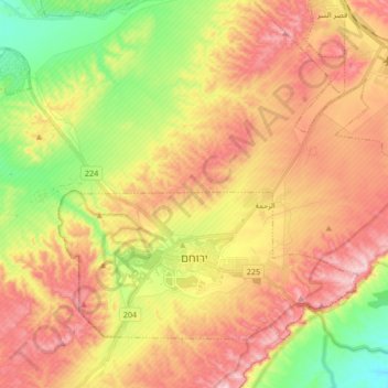
Name: Yeruham topographic map, elevation, terrain.
Location: Yeruham, Beersheba Subdistrict, South District, Israel (30.95881 34.82864 31.06671 34.99631)
Average elevation: 508 m
Minimum elevation: 320 m
Maximum elevation: 686 m
Other topographic maps
Click on a map to view its topography, its elevation and its terrain.
Matmor Mountains lookout
Israel > South District > Ramat Negev Regional Council
Average elevation: 410 m
Mitzpe Ramon
Mitzpe Ramon (Hebrew: מִצְפֵּה רָמוֹן, Ramon Lookout; Arabic: متسبي رمون) is a local council in the Negev desert of southern Israel. It is situated on the northern ridge at an elevation of 860 meters (2,800 feet) overlooking the world's largest erosion cirque, known as the Makhtesh…
Average elevation: 778 m
Arad
Israel > South District > Arad
The plan took into account topography and climate, with residential buildings constructed with large inner courtyards that offered protection from the desert sun and wind. High density residential areas were built first in order to create an urban milieu and shorten walking distances.
Average elevation: 579 m
Dimona
Israel > South District > Dimona
Dimona is located in the Negev Desert. The city stands at an elevation of around 550–600 metres (1,800–1,970 ft) above sea level.
Average elevation: 554 m
Kisufim
Israel > South District > Eshkol Regional Council
Kissufim (Hebrew: כִּסּוּפִים, lit. 'Yearning') is a kibbutz in the northwestern Negev desert in Israel. Located adjacent to the Gaza Strip at an altitude of 92 m (302 ft) above sea level, it falls under the jurisdiction of Eshkol Regional Council. In 2023 it had a population of 343.
Average elevation: 78 m
Nizzana
Israel > South District > Beersheba Subdistrict > Ramat Negev Regional Council > Nizzana
Average elevation: 236 m