
Thank you for supporting this site ❤️
Make a donation
Make a donation
Phakding topographic map
Click on the map to display elevation.
Thank you for supporting this site ❤️
Make a donation
Make a donation
Phakding
Phakding is a small village in the Khumbu region of Nepal. It lies in the Dudh Kosi river valley just north of Lukla and south of Monjo, at an altitude of 2,610 m. It has been a UNESCO World Heritage Site since 1979. Phakding has a population of 550 locals, mostly Sherpa and Tamang. All of these people belong to Tibetan Buddhism and pray in a small Gompa at the centre of the village.
Thank you for supporting this site ❤️
Make a donation
Make a donation
About this map
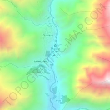
Name: Phakding topographic map, elevation, terrain.
Location: Phakding, Khumbupasanglahmu, Solukhumbu, Koshi Province, Nepal (27.72013 86.69269 27.76013 86.73269)
Average elevation: 3,111 m
Minimum elevation: 2,503 m
Maximum elevation: 4,121 m
Thank you for supporting this site ❤️
Make a donation
Make a donation
Other topographic maps
Click on a map to view its topography, its elevation and its terrain.