
Thank you for supporting this site ❤️
Make a donation
Make a donation
Clarkston topographic map
Click on the map to display elevation.
Thank you for supporting this site ❤️
Make a donation
Make a donation
About this map
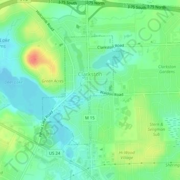
Name: Clarkston topographic map, elevation, terrain.
Location: Clarkston, Oakland County, Michigan, United States (42.72524 -83.42857 42.74159 -83.41286)
Average elevation: 308 m
Minimum elevation: 291 m
Maximum elevation: 340 m
Thank you for supporting this site ❤️
Make a donation
Make a donation
Other topographic maps
Click on a map to view its topography, its elevation and its terrain.
Oakley Park
United States > Michigan > Oakland County > Commerce Charter Township
Average elevation: 282 m
Thank you for supporting this site ❤️
Make a donation
Make a donation