
Thank you for supporting this site ❤️
Make a donation
Make a donation
Amlwch topographic map
Click on the map to display elevation.
Thank you for supporting this site ❤️
Make a donation
Make a donation
About this map
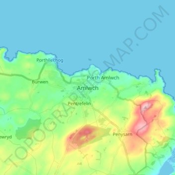
Name: Amlwch topographic map, elevation, terrain.
Location: Amlwch, Isle of Anglesey, Wales, LL68 9EU, United Kingdom (53.36903 -4.38265 53.44903 -4.30265)
Average elevation: 38 m
Minimum elevation: 0 m
Maximum elevation: 174 m
Thank you for supporting this site ❤️
Make a donation
Make a donation
Other topographic maps
Click on a map to view its topography, its elevation and its terrain.
Llanfairpwllgwyngyll
United Kingdom > Wales > Isle of Anglesey > Llanfairpwllgwyngyll
Average elevation: 42 m