
Make a donation
San Guillermo topographic map
Click on the map to display elevation.
Make a donation
About this map
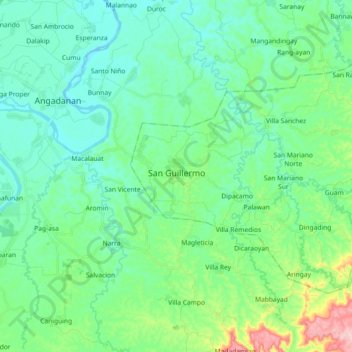
Name: San Guillermo topographic map, elevation, terrain.
Location: San Guillermo, Isabela, Cagayan Valley, 3308, Philippines (16.66134 121.78559 16.77684 121.96752)
Average elevation: 92 m
Minimum elevation: 40 m
Maximum elevation: 281 m
Make a donation
Other topographic maps
Click on a map to view its topography, its elevation and its terrain.
Ilagan
Abuan River is the main river of the Northern Sierra Madre Natural Park. It has an average elevation of 82 meters above sea level, and feeds the Abuan watershed in the city. Tourists and visitors can explore the diverse animal and plant life in one of the country’s remaining lush virgin forests. On January…
Average elevation: 123 m
Make a donation
Make a donation
Jones
Jones is primarily an agricultural municipality best suited for the intensive production of rice and corn as evidence by its topographic map which shows that 73% of the agricultural area of 16,848 hectares is under 0-3 slope category.
Average elevation: 99 m
Make a donation
Make a donation
Make a donation
San Mateo
The terrain of the municipality is basically plain with 98% of the total land area under 0-2 percent slope category and only 2% of the total area is under the 2.3-5 percent slope category. The excellent topography of the municipality has made irrigation by gravity method applicable in flooding of rice paddies.
Average elevation: 81 m
Make a donation
Make a donation
Make a donation
Make a donation
Roxas
The landscape of Roxas is relatively compose of flatlands with minimal rise at certain point with base mountain elevations on the eastern part, on the parts of Sinamar, Simimbaan and San Placido. It is approximately 90% of the land area comprising the town can be described as low-lying hills with rolling…
Average elevation: 59 m
Make a donation
Make a donation
Make a donation
Make a donation
Make a donation
Make a donation
Make a donation
Make a donation
Make a donation
Make a donation
Make a donation
Make a donation
Make a donation
Make a donation
Ilagan
Abuan River is the main river of the Northern Sierra Madre Natural Park. It has an average elevation of 82 meters above sea level, and feeds the Abuan watershed in the city. Tourists and visitors can explore the diverse animal and plant life in one of the country’s remaining lush virgin forests. On January…
Average elevation: 123 m
Make a donation