
Make a donation
Governors Club topographic map
Click on the map to display elevation.
Make a donation
About this map
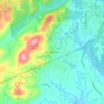
Name: Governors Club topographic map, elevation, terrain.
Average elevation: 107 m
Minimum elevation: 68 m
Maximum elevation: 199 m
Make a donation
Other topographic maps
Click on a map to view its topography, its elevation and its terrain.
Jordan Lake
United States > North Carolina > Chatham County
The Jordan Lake Dam (also known as the B. Everett Jordan Project and the New Hope Dam) is located at 35°39′15″N 79°4′0″W / 35.65417°N 79.06667°W / 35.65417; -79.06667 (B. Everett Jordan Dam) 4 miles (6.4 km) upstream from the mouth of the Haw River in the upper Cape Fear River drainage…
Average elevation: 102 m
Make a donation
Jordan Lake
United States > North Carolina > Chatham County
The Jordan Lake Dam (also known as the B. Everett Jordan Project and the New Hope Dam) is located at 35°39′15″N 79°4′0″W / 35.65417°N 79.06667°W / 35.65417; -79.06667 (B. Everett Jordan Dam) 4 miles (6.4 km) upstream from the mouth of the Haw River in the upper Cape Fear River drainage…
Average elevation: 102 m
Make a donation
Fearrington Village
United States > North Carolina > Chatham County > Fearrington
Average elevation: 127 m
Town of Pittsboro
United States > North Carolina > Chatham County > Town of Pittsboro
Average elevation: 123 m
Make a donation