
Thank you for supporting this site ❤️
Make a donation
Make a donation
Big Bald topographic map
Click on the map to display elevation.
Thank you for supporting this site ❤️
Make a donation
Make a donation
About this map
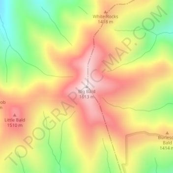
Name: Big Bald topographic map, elevation, terrain.
Location: Big Bald, Mitchell County, North Carolina, United States (35.98757 -82.05934 35.98767 -82.05924)
Average elevation: 1,331 m
Minimum elevation: 1,022 m
Maximum elevation: 1,592 m
Thank you for supporting this site ❤️
Make a donation
Make a donation
Other topographic maps
Click on a map to view its topography, its elevation and its terrain.
North Toe River
United States > North Carolina > Mitchell County > Spruce Pine
Average elevation: 824 m
Thank you for supporting this site ❤️
Make a donation
Make a donation