
Thank you for supporting this site ❤️
Make a donation
Make a donation
Sparkill topographic map
Click on the map to display elevation.
Thank you for supporting this site ❤️
Make a donation
Make a donation
About this map
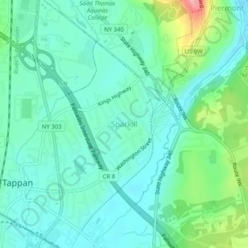
Name: Sparkill topographic map, elevation, terrain.
Average elevation: 30 m
Minimum elevation: 2 m
Maximum elevation: 120 m
Thank you for supporting this site ❤️
Make a donation
Make a donation
Other topographic maps
Click on a map to view its topography, its elevation and its terrain.
Kings Gate Park
United States > New York > Rockland County > Village of Montebello
Average elevation: 154 m
Evans Park Trail/Woods
United States > New York > Rockland County > Pearl River
Average elevation: 82 m
Thank you for supporting this site ❤️
Make a donation
Make a donation
Thank you for supporting this site ❤️
Make a donation
Make a donation