
Thank you for supporting this site ❤️
Make a donation
Make a donation
Xining City topographic map
Click on the map to display elevation.
Thank you for supporting this site ❤️
Make a donation
Make a donation
About this map
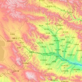
Name: Xining City topographic map, elevation, terrain.
Location: Xining City, Qinghai, China (36.22969 100.87031 37.46987 101.91223)
Average elevation: 3,215 m
Minimum elevation: 2,072 m
Maximum elevation: 4,799 m
Thank you for supporting this site ❤️
Make a donation
Make a donation
Other topographic maps
Click on a map to view its topography, its elevation and its terrain.
Golog Tibetan Autonomous Prefecture
China > Qinghai > Gadê County
The lay of the land of the prefecture is largely determined by the Amne Machin mountain range (max elevation 6,282 m), which runs in the general northwest- to-southeast direction across the entire prefecture, and beyond. The existence of the ridge results in one of the great bends of the Yellow River, which…
Average elevation: 4,340 m