
Thank you for supporting this site ❤️
Make a donation
Make a donation
Chestertown topographic map
Click on the map to display elevation.
Thank you for supporting this site ❤️
Make a donation
Make a donation
Chestertown
Chestertown is located at 43°39′09″N 073°48′03″W / 43.65250°N 73.80083°W / 43.65250; -73.80083 (43.6525664, -73.8009597) and its elevation is 896 feet (273 m). The ZIP code is 12817 and it is in the Eastern Time Zone. The nearest city is Glens Falls.
Thank you for supporting this site ❤️
Make a donation
Make a donation
About this map
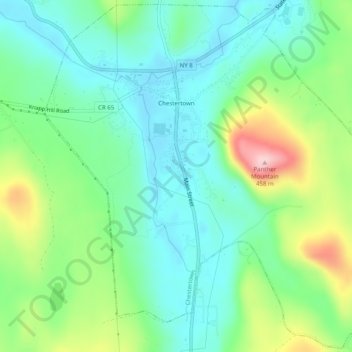
Name: Chestertown topographic map, elevation, terrain.
Average elevation: 307 m
Minimum elevation: 244 m
Maximum elevation: 454 m
Thank you for supporting this site ❤️
Make a donation
Make a donation
Other topographic maps
Click on a map to view its topography, its elevation and its terrain.
Big Bear Mountain
United States > New York > Warren County > Town of Johnsburg
Average elevation: 616 m
French Mountain
United States > New York > Warren County > Town of Queensbury
Average elevation: 317 m
Thank you for supporting this site ❤️
Make a donation
Make a donation
Thank you for supporting this site ❤️
Make a donation
Make a donation
Thank you for supporting this site ❤️
Make a donation
Make a donation