
Thank you for supporting this site ❤️
Make a donation
Make a donation
Sakhuwa topographic map
Click on the map to display elevation.
Thank you for supporting this site ❤️
Make a donation
Make a donation
About this map
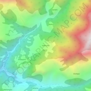
Name: Sakhuwa topographic map, elevation, terrain.
Average elevation: 1,205 m
Minimum elevation: 626 m
Maximum elevation: 2,211 m
Thank you for supporting this site ❤️
Make a donation
Make a donation
Other topographic maps
Click on a map to view its topography, its elevation and its terrain.
Arun River
Nepal > Koshi Province > Sankhuwasabha > Num
The Tibetan name Bum-chu may refer to a religious ceremony attempting to divine prospects for the coming year from the level of water in a pot or well, chu is the Tibetan word for water. The river originates near Gutso in Nyalam County of Tibet. Around 17 kilometres (11 mi) downstream, the Men-chu joins it.…
Average elevation: 1,153 m
Thank you for supporting this site ❤️
Make a donation
Make a donation