
Thank you for supporting this site ❤️
Make a donation
Make a donation
Laga topographic map
Click on the map to display elevation.
Thank you for supporting this site ❤️
Make a donation
Make a donation
About this map
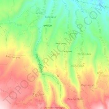
Name: Laga topographic map, elevation, terrain.
Average elevation: 275 m
Minimum elevation: 99 m
Maximum elevation: 462 m
Thank you for supporting this site ❤️
Make a donation
Make a donation
Other topographic maps
Click on a map to view its topography, its elevation and its terrain.
Municipality of Agios Vasileios
Greece > Region of Crete > Rethymno Regional Unit
Average elevation: 247 m
Myli Gorge
Greece > Region of Crete > Rethymno Regional Unit > Xiro Chorio > Myli
Average elevation: 198 m
Thank you for supporting this site ❤️
Make a donation
Make a donation