
Thank you for supporting this site ❤️
Make a donation
Make a donation
Springfontein topographic map
Click on the map to display elevation.
Thank you for supporting this site ❤️
Make a donation
Make a donation
About this map
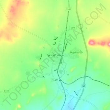
Name: Springfontein topographic map, elevation, terrain.
Average elevation: 1,529 m
Minimum elevation: 1,467 m
Maximum elevation: 1,648 m
Thank you for supporting this site ❤️
Make a donation
Make a donation
Other topographic maps
Click on a map to view its topography, its elevation and its terrain.
Gariep Dam
South Africa > Free State > Xhariep District Municipality > Kopanong Local Municipality
Average elevation: 1,317 m
Tierpoort
South Africa > Free State > Xhariep District Municipality > Kopanong Local Municipality
Average elevation: 1,301 m