
Thank you for supporting this site ❤️
Make a donation
Make a donation
Marousi topographic map
Click on the map to display elevation.
Thank you for supporting this site ❤️
Make a donation
Make a donation
About this map
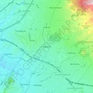
Name: Marousi topographic map, elevation, terrain.
Average elevation: 257 m
Minimum elevation: 125 m
Maximum elevation: 783 m
Thank you for supporting this site ❤️
Make a donation
Make a donation
Other topographic maps
Click on a map to view its topography, its elevation and its terrain.
Municipality of Agia Paraskevi
Greece > Attica > Regional Unit of North Athens
Average elevation: 269 m
Municipal Unit of Neo Psychiko
Greece > Attica > Regional Unit of North Athens
Average elevation: 191 m
Nea Penteli Municipal Unit
Greece > Attica > Regional Unit of North Athens > Nea Penteli Municipal Unit
Average elevation: 496 m
Thank you for supporting this site ❤️
Make a donation
Make a donation
Municipality of Chalandri
Greece > Attica > Regional Unit of North Athens > Municipality of Chalandri
Average elevation: 208 m