
Thank you for supporting this site ❤️
Make a donation
Make a donation
Gulph topographic map
Click on the map to display elevation.
Thank you for supporting this site ❤️
Make a donation
Make a donation
About this map
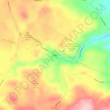
Name: Gulph topographic map, elevation, terrain.
Average elevation: 388 m
Minimum elevation: 281 m
Maximum elevation: 468 m
Thank you for supporting this site ❤️
Make a donation
Make a donation
Other topographic maps
Click on a map to view its topography, its elevation and its terrain.
East Frankfort
United States > New York > Herkimer County > Town of Frankfort
Average elevation: 152 m