
Wallbach topographic map
Interactive map
Click on the map to display elevation.
About this map
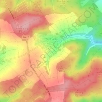
Name: Wallbach topographic map, elevation, terrain.
Location: Wallbach, Hünstetten, Rheingau-Taunus-Kreis, Hessen, Deutschland (50.23656 8.18467 50.25759 8.21996)
Average elevation: 369 m
Minimum elevation: 284 m
Maximum elevation: 418 m
Other topographic maps
Click on a map to view its topography, its elevation and its terrain.
Wallrabenstein
Deutschland > Hessen > Rheingau-Taunus-Kreis > Hünstetten
Wallrabenstein, Hünstetten, Rheingau-Taunus-Kreis, Hessen, Deutschland
Average elevation: 275 m
Görsroth
Deutschland > Hessen > Rheingau-Taunus-Kreis > Hünstetten
Görsroth, Hünstetten, Rheingau-Taunus-Kreis, Hessen, Deutschland
Average elevation: 367 m
Wallrabenstein
Deutschland > Hessen > Rheingau-Taunus-Kreis > Hünstetten > Wallrabenstein
Wallrabenstein, Hünstetten, Rheingau-Taunus-Kreis, Hessen, 65510, Deutschland
Average elevation: 272 m