
Thank you for supporting this site ❤️
Make a donation
Make a donation
Punta de las Olas topographic map
Click on the map to display elevation.
Thank you for supporting this site ❤️
Make a donation
Make a donation
About this map
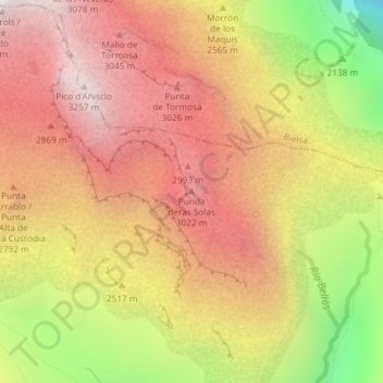
Name: Punta de las Olas topographic map, elevation, terrain.
Location: Punta de las Olas, Sobrarbe, Huesca, Aragón, España (42.66214 0.05342 42.66224 0.05352)
Average elevation: 2,556 m
Minimum elevation: 1,464 m
Maximum elevation: 3,298 m
Thank you for supporting this site ❤️
Make a donation
Make a donation
Other topographic maps
Click on a map to view its topography, its elevation and its terrain.