
Thank you for supporting this site ❤️
Make a donation
Make a donation
Aminit Cell topographic map
Click on the map to display elevation.
Thank you for supporting this site ❤️
Make a donation
Make a donation
About this map
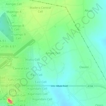
Name: Aminit Cell topographic map, elevation, terrain.
Location: Aminit Cell, Soroti, Eastern Region, Uganda (1.70772 33.61673 1.74772 33.65673)
Average elevation: 1,113 m
Minimum elevation: 1,084 m
Maximum elevation: 1,183 m
Thank you for supporting this site ❤️
Make a donation
Make a donation