
Make a donation
Oder topographic map
Click on the map to display elevation.
Make a donation
About this map
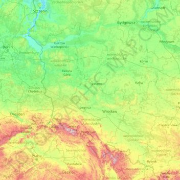
Name: Oder topographic map, elevation, terrain.
Location: Oder, Poland (49.61342 14.12287 53.59643 18.35168)
Average elevation: 194 m
Minimum elevation: -2 m
Maximum elevation: 1,469 m
Make a donation
Other topographic maps
Click on a map to view its topography, its elevation and its terrain.
Make a donation
Wzgórze Grodowe
Poland > West Pomeranian Voivodeship > Pyrzyce County > Lipiany
Average elevation: 67 m
Make a donation
Make a donation
Śnieżka / Sněžka
Poland > Lower Silesian Voivodeship > Karkonosze County > Karpacz
Due to high altitude the climate is maritime polar (Köppen: ET) not far from a continental subpolar climate (Dfc). The difference should be at least 6 °C lower on annual average compared to the weather station in the plains.
Average elevation: 1,263 m
Make a donation
Make a donation
Make a donation
Majewo-Kolonia
Poland > Warmian-Masurian Voivodeship > Elbląg County > Majewo
Average elevation: 142 m
Klein
Poland > Lesser Poland Voivodeship > Oświęcim County > Stawy Monowskie > Zalesie
Average elevation: 226 m
Make a donation
Svinica / Świnica
Poland > Lesser Poland Voivodeship > Tatra County > Brzegi
Average elevation: 1,857 m
Sudety
Poland > Lower Silesian Voivodeship > Ząbkowice Śląskie County > Starczówek
Average elevation: 293 m
Make a donation
Make a donation
Make a donation
Make a donation
Jezioro Żarnowieckie
Poland > Pomeranian Voivodeship > Wejherowo County > Czymanowo
Average elevation: 37 m
Wielki Giewont
Poland > Lesser Poland Voivodeship > Tatra County > Zakopane
Average elevation: 1,478 m
Make a donation
Szary Kamień
Poland > Lower Silesian Voivodeship > Kłodzko County > Lądek-Zdrój
Average elevation: 492 m
Make a donation
Polanica
Poland > Lower Silesian Voivodeship > Ząbkowice Śląskie County > Nowina
Average elevation: 247 m
Make a donation
Podzamcze
Poland > Lesser Poland Voivodeship > Kraków County > Korzkiew > Podzamcze
Average elevation: 321 m
Make a donation
Podkościele
Poland > Lesser Poland Voivodeship > Tarnów County > Wola Rzędzińska
Average elevation: 240 m
Make a donation
Morskie Oko
Poland > Lesser Poland Voivodeship > Tatra County > Brzegi
Morskie Oko at the foothill of Tatra Mountains in southern Poland which average 2,000 metres (6,600 ft) in elevation
Average elevation: 1,749 m
Make a donation
Modlin
Poland > Greater Poland Voivodeship > Ostrów Wielkopolski County > Zamość
Average elevation: 131 m
Make a donation
Make a donation
Tatry
Poland > Lesser Poland Voivodeship > Tatra County > Zakopane
The Tatras lie in the temperate zone of Central Europe. They are an important barrier to the movements of air masses. Their mountainous topography causes one of the most diverse climates in that region.
Average elevation: 1,647 m
Make a donation
Make a donation
Szczuczyn
Poland > Podlaskie Voivodeship > Grajewo County > Szczuczyn > Szczuczyn
Average elevation: 138 m
Święty Krzyż
Poland > Lesser Poland Voivodeship > Nowy Sącz County > Królowa Polska > Góry
Average elevation: 463 m
Make a donation
Make a donation
Make a donation
Make a donation