
Thank you for supporting this site ❤️
Make a donation
Make a donation
Rome topographic map
Click on the map to display elevation.
Thank you for supporting this site ❤️
Make a donation
Make a donation
About this map
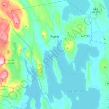
Name: Rome topographic map, elevation, terrain.
Location: Rome, Kennebec County, Maine, United States (44.51231 -69.94754 44.62152 -69.81657)
Average elevation: 118 m
Minimum elevation: 70 m
Maximum elevation: 356 m
Thank you for supporting this site ❤️
Make a donation
Make a donation
Other topographic maps
Click on a map to view its topography, its elevation and its terrain.