
Thank you for supporting this site ❤️
Make a donation
Make a donation
Sheriff Hill topographic map
Click on the map to display elevation.
Thank you for supporting this site ❤️
Make a donation
Make a donation
About this map
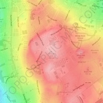
Name: Sheriff Hill topographic map, elevation, terrain.
Average elevation: 118 m
Minimum elevation: 23 m
Maximum elevation: 166 m
Thank you for supporting this site ❤️
Make a donation
Make a donation
Other topographic maps
Click on a map to view its topography, its elevation and its terrain.
Silverhill Wood
United Kingdom > England > Tyne and Wear > Gateshead > Lamesley
Average elevation: 123 m
Winlaton Mill Millennium Green
United Kingdom > England > Tyne and Wear > Gateshead > Winlaton Mill
Average elevation: 75 m
Thank you for supporting this site ❤️
Make a donation
Make a donation