
Make a donation
Brooktrails topographic map
Click on the map to display elevation.
Make a donation
Brooktrails
Brooktrails is in central Mendocino County, occupying hills to the west of Little Lake Valley. The fire department and golf course lie at an elevation of 1,634 feet (498 m), but the community's western edge rises to nearly 3,000 feet (910 m). It is 3 miles (5 km) north of Willits. According to the United States Census Bureau, the CDP covers an area of 7.3 square miles (19 km2), 99.36% of it land, and 0.64% of it water.
Make a donation
About this map
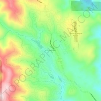
Name: Brooktrails topographic map, elevation, terrain.
Location: Brooktrails, Mendocino County, California, United States (39.42377 -123.40529 39.46377 -123.36529)
Average elevation: 569 m
Minimum elevation: 405 m
Maximum elevation: 814 m
Make a donation
Other topographic maps
Click on a map to view its topography, its elevation and its terrain.
Fort Bragg
United States > California > Mendocino County
Fort Bragg, officially the City of Fort Bragg, is a city along the Pacific Coast of California along Shoreline Highway in Mendocino County. The city is 24 miles (39 km) west of Willits, at an elevation of 85 feet (26 m). Its population was 6,983 at the 2020 census.
Average elevation: 8 m
Talmage
United States > California > Mendocino County
Talmage (variant, Talmadge) is a census-designated place (CDP) in Mendocino County, California, United States. Talmage is located 2.5 miles (4 km) east-southeast of Ukiah, at an elevation of 627 feet (191 m). The population was 986 at the 2020 census, down from 1,130 in 2010. It lies in the southeastern part…
Average elevation: 200 m
Hopland
United States > California > Mendocino County > Hopland
Hopland (formerly Sanel) is a census-designated place in Mendocino County, California, United States. It is located on the west bank of the Russian River 13 miles (21 km) south-southeast of Ukiah, in the Sanel Valley, at an elevation of 502 feet (153 m). The population was 661 at the 2020 census, down from 756…
Average elevation: 165 m
Fort Bragg
United States > California > Mendocino County
Fort Bragg is a city along the Pacific Coast of California along Shoreline Highway in Mendocino County. The city is 24 miles (39 km) west of Willits, at an elevation of 85 feet (26 m). Its population was 6,983 at the 2020 census.
Average elevation: 24 m
Make a donation
Fort Bragg
United States > California > Mendocino County
Fort Bragg is a city along the North Coast of California along in Mendocino County. The city is 24 miles (39 km) west of Willits, at an elevation of 85 feet (26 m). Its population was 6,983 at the 2020 census.
Average elevation: 29 m
Point Arena
United States > California > Mendocino County
Point Arena, formerly known as Punta Arena (Spanish for "Sandy Point") is a small coastal city in Mendocino County, California, United States. Point Arena is located 32 miles (51 km) west of Hopland, at an elevation of 118 feet (36 m). The population was 460 at the 2020 census, making it one of the smallest…
Average elevation: 12 m
East Fork Russian River
United States > California > Mendocino County > Potter Valley
Average elevation: 412 m
Make a donation