
Thank you for supporting this site ❤️
Make a donation
Make a donation
Rome topographic map
Click on the map to display elevation.
Thank you for supporting this site ❤️
Make a donation
Make a donation
About this map
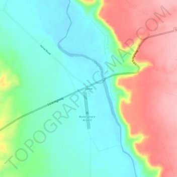
Name: Rome topographic map, elevation, terrain.
Location: Rome, Malheur County, Oregon, United States (42.81830 -117.64852 42.85830 -117.60852)
Average elevation: 1,075 m
Minimum elevation: 1,022 m
Maximum elevation: 1,161 m
Thank you for supporting this site ❤️
Make a donation
Make a donation
Other topographic maps
Click on a map to view its topography, its elevation and its terrain.
Vale
United States > Oregon > Malheur County
According to the United States Census Bureau, the city has a total area of 1.14 square miles (2.95 km2), all of it land. The city has an elevation of 2,244 feet (684 m) above sea level.
Average elevation: 710 m