
Make a donation
Decide topographic map
Click on the map to display elevation.
Make a donation
About this map
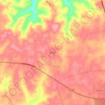
Name: Decide topographic map, elevation, terrain.
Location: Decide, Clinton County, Kentucky, United States (36.75340 -85.22413 36.79340 -85.18413)
Average elevation: 293 m
Minimum elevation: 202 m
Maximum elevation: 324 m
Make a donation
Other topographic maps
Click on a map to view its topography, its elevation and its terrain.
Albany
United States > Kentucky > Clinton County
Albany is located in south-central Clinton County at 36°41′36″N 85°8′7″W / 36.69333°N 85.13528°W / 36.69333; -85.13528 (36.693280, -85.135286). The city lies at an elevation of 960 feet (290 m) at the foot of the western edge of the Cumberland Plateau. Albany Rock, a western spur of the…
Average elevation: 310 m