
Thank you for supporting this site ❤️
Make a donation
Make a donation
Forbestown topographic map
Click on the map to display elevation.
Thank you for supporting this site ❤️
Make a donation
Make a donation
Forbestown
Forbestown (formerly, Boles Dry Diggins and Forbes Diggins) is a census-designated place in Butte County, California. It lies at an elevation of 2772 feet (845 m). Its zip code is 95941 and its area code is 530. Forbestown had a population of 320 at the 2010 census.
Thank you for supporting this site ❤️
Make a donation
Make a donation
About this map
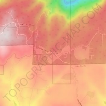
Name: Forbestown topographic map, elevation, terrain.
Location: Forbestown, Butte County, California, 95941, United States (39.49711 -121.28718 39.53711 -121.24718)
Average elevation: 809 m
Minimum elevation: 351 m
Maximum elevation: 1,004 m
Thank you for supporting this site ❤️
Make a donation
Make a donation
Other topographic maps
Click on a map to view its topography, its elevation and its terrain.
Thank you for supporting this site ❤️
Make a donation
Make a donation
Thank you for supporting this site ❤️
Make a donation
Make a donation