
Thank you for supporting this site ❤️
Make a donation
Make a donation
Al Wajh topographic map
Click on the map to display elevation.
Thank you for supporting this site ❤️
Make a donation
Make a donation
About this map
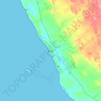
Name: Al Wajh topographic map, elevation, terrain.
Location: Al Wajh, Tabuk Province, Saudi Arabia (26.08442 36.29328 26.40442 36.61328)
Average elevation: 39 m
Minimum elevation: -2 m
Maximum elevation: 231 m
Thank you for supporting this site ❤️
Make a donation
Make a donation
Other topographic maps
Click on a map to view its topography, its elevation and its terrain.