
Thank you for supporting this site ❤️
Make a donation
Make a donation
La Molata topographic map
Click on the map to display elevation.
Thank you for supporting this site ❤️
Make a donation
Make a donation
About this map
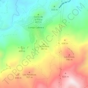
Name: La Molata topographic map, elevation, terrain.
Location: La Molata, Turre, Almería, Andalucía, España (37.10768 -1.91508 37.10778 -1.91498)
Average elevation: 469 m
Minimum elevation: 139 m
Maximum elevation: 912 m
Thank you for supporting this site ❤️
Make a donation
Make a donation
Other topographic maps
Click on a map to view its topography, its elevation and its terrain.