
Make a donation
West Point topographic map
Click on the map to display elevation.
Make a donation
About this map
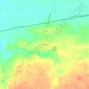
Name: West Point topographic map, elevation, terrain.
Location: West Point, Tippecanoe County, Indiana, 47992, United States (40.32468 -87.06218 40.36468 -87.02218)
Average elevation: 198 m
Minimum elevation: 176 m
Maximum elevation: 222 m
Make a donation
Other topographic maps
Click on a map to view its topography, its elevation and its terrain.
Dayton
United States > Indiana > Tippecanoe County
Dayton is located in northwest Sheffield Township, at an elevation of 676 feet (206 m).
Average elevation: 203 m
Battle Ground
United States > Indiana > Tippecanoe County
Battle Ground is located at 40°30′36″N 86°50′18″W / 40.51000°N 86.83833°W / 40.51000; -86.83833 (40.510110, −86.838220) in Tippecanoe Township, one and a quarter miles northwest of the Wabash River. Its elevation is approximately 585 feet. The small Harrison Creek begins near Battle…
Average elevation: 180 m
Make a donation