
Larrebidea topographic map
Interactive map
Click on the map to display elevation.
About this map
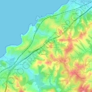
Name: Larrebidea topographic map, elevation, terrain.
Average elevation: 30 m
Minimum elevation: -1 m
Maximum elevation: 87 m
Other topographic maps
Click on a map to view its topography, its elevation and its terrain.
Iratzea
France > Nouvelle-Aquitaine > Pyrénées-Atlantiques > Saint-Jean-de-Luz
Iratzea, Saint-Jean-de-Luz, Bayonne, Pyrénées-Atlantiques, Nouvelle-Aquitaine, France métropolitaine, 64500, France
Average elevation: 18 m
Urthaburu
France > Nouvelle-Aquitaine > Pyrénées-Atlantiques > Saint-Jean-de-Luz > Urthaburu
Urthaburu, Saint-Jean-de-Luz, Bayonne, Pyrénées-Atlantiques, Nouvelle-Aquitaine, France métropolitaine, 64500, France
Average elevation: 27 m
Acotz
France > Nouvelle-Aquitaine > Pyrénées-Atlantiques > Saint-Jean-de-Luz > Acotz
Acotz, Saint-Jean-de-Luz, Bayonne, Pyrénées-Atlantiques, Nouvelle-Aquitaine, France métropolitaine, 64500, France
Average elevation: 25 m
Urdazuri
France > Nouvelle-Aquitaine > Pyrénées-Atlantiques > Saint-Jean-de-Luz
Urdazuri, Saint-Jean-de-Luz, Bayonne, Pyrénées-Atlantiques, Nouvelle-Aquitaine, France métropolitaine, 64500, France
Average elevation: 23 m