
Thank you for supporting this site ❤️
Make a donation
Make a donation
Diktel topographic map
Click on the map to display elevation.
Thank you for supporting this site ❤️
Make a donation
Make a donation
Diktel
Diktel was renamed to Rupakot Majhuwagadhi on 10 March 2017 after merging some more VDCs. The municipality is divided into 15 wards. It is on 700 m to 2250 m of elevation from sea level. The area of the municipality is 246.51 km2. There are 10,050 households with population of 46,903. By 2020, the name commonly used name Diktel was re-added to the municipality's official name.
Thank you for supporting this site ❤️
Make a donation
Make a donation
About this map
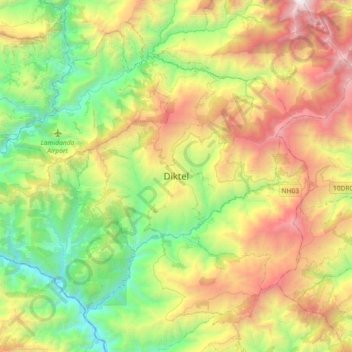
Name: Diktel topographic map, elevation, terrain.
Location: Diktel, Rupakot Majhuwagadhi, Khotang, Koshi Province, Nepal (27.05328 86.63318 27.37328 86.95318)
Average elevation: 1,505 m
Minimum elevation: 252 m
Maximum elevation: 3,602 m
Thank you for supporting this site ❤️
Make a donation
Make a donation
Other topographic maps
Click on a map to view its topography, its elevation and its terrain.