
Thank you for supporting this site ❤️
Make a donation
Make a donation
Pallivasal topographic map
Click on the map to display elevation.
Thank you for supporting this site ❤️
Make a donation
Make a donation
About this map
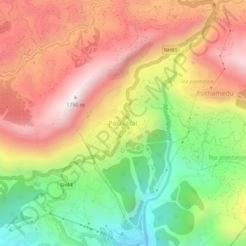
Name: Pallivasal topographic map, elevation, terrain.
Location: Pallivasal, Devikulam, Idukki District, Kerala, 685565, India (10.02978 77.03148 10.06978 77.07148)
Average elevation: 1,305 m
Minimum elevation: 818 m
Maximum elevation: 1,755 m
Thank you for supporting this site ❤️
Make a donation
Make a donation
Other topographic maps
Click on a map to view its topography, its elevation and its terrain.