
Thank you for supporting this site ❤️
Make a donation
Make a donation
Edwardsville topographic map
Click on the map to display elevation.
Thank you for supporting this site ❤️
Make a donation
Make a donation
About this map
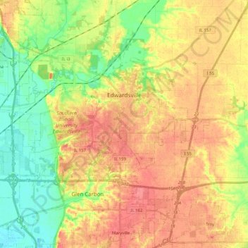
Name: Edwardsville topographic map, elevation, terrain.
Location: Edwardsville, Madison County, Illinois, United States (38.76021 -90.08611 38.82536 -89.88358)
Average elevation: 156 m
Minimum elevation: 124 m
Maximum elevation: 184 m
Thank you for supporting this site ❤️
Make a donation
Make a donation
Other topographic maps
Click on a map to view its topography, its elevation and its terrain.