
Thank you for supporting this site ❤️
Make a donation
Make a donation
Tigo Balai topographic map
Click on the map to display elevation.
Thank you for supporting this site ❤️
Make a donation
Make a donation
About this map
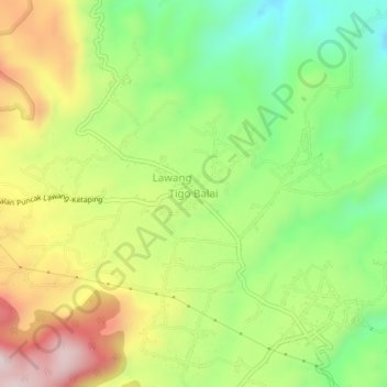
Name: Tigo Balai topographic map, elevation, terrain.
Location: Tigo Balai, Agam, West Sumatra, Sumatra, Indonesia (-0.28599 100.25327 -0.24599 100.29327)
Average elevation: 1,045 m
Minimum elevation: 821 m
Maximum elevation: 1,332 m
Thank you for supporting this site ❤️
Make a donation
Make a donation
Other topographic maps
Click on a map to view its topography, its elevation and its terrain.