
Thank you for supporting this site ❤️
Make a donation
Make a donation
Walhalla topographic map
Click on the map to display elevation.
Thank you for supporting this site ❤️
Make a donation
Make a donation
About this map
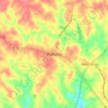
Name: Walhalla topographic map, elevation, terrain.
Average elevation: 296 m
Minimum elevation: 249 m
Maximum elevation: 330 m
Thank you for supporting this site ❤️
Make a donation
Make a donation
Other topographic maps
Click on a map to view its topography, its elevation and its terrain.
Woodland Trailer Park
United States > South Carolina > Oconee County > Walhalla
Average elevation: 303 m
Thank you for supporting this site ❤️
Make a donation
Make a donation
Thank you for supporting this site ❤️
Make a donation
Make a donation
Thank you for supporting this site ❤️
Make a donation
Make a donation
George Martin Acres
United States > South Carolina > Oconee County > George Martin Acres
Average elevation: 253 m