
Thank you for supporting this site ❤️
Make a donation
Make a donation
Luarca topographic map
Click on the map to display elevation.
Thank you for supporting this site ❤️
Make a donation
Make a donation
About this map
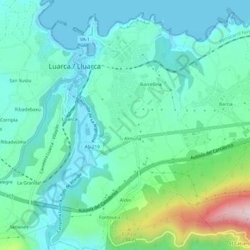
Name: Luarca topographic map, elevation, terrain.
Location: Luarca, Valdés, Asturias, 33700, España (43.51944 -6.54543 43.55255 -6.51184)
Average elevation: 86 m
Minimum elevation: 0 m
Maximum elevation: 397 m
Thank you for supporting this site ❤️
Make a donation
Make a donation
Other topographic maps
Click on a map to view its topography, its elevation and its terrain.
Thank you for supporting this site ❤️
Make a donation
Make a donation
Thank you for supporting this site ❤️
Make a donation
Make a donation