
Meghalaya topographic map
Interactive map
Click on the map to display elevation.
About this map
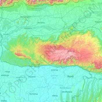
Name: Meghalaya topographic map, elevation, terrain.
Location: Meghalaya, India (25.03065 89.81444 26.11817 92.80274)
Average elevation: 244 m
Minimum elevation: 0 m
Maximum elevation: 2,336 m
Meghalaya, alongside neighbouring Indian states, has been of archaeological interest. People have lived in Meghalaya since the Neolithic period. Neolithic sites discovered so far are located in areas of high elevation in Khasi Hills, Garo Hills and in neighbouring states, where Neolithic style jhum or shifting cultivation is practiced even today. The highland plateaus fed by abundant rains provided safety from floods and a rich soil. The importance of Meghalaya is its possible role in human history via domestication of rice. One of the competing theories for the origin of rice comes from Ian Glover, who states, "India is the center of greatest diversity of domesticated rice with over 20,000 identified species and Northeast India is the most favorable single area of the origin of domesticated rice." The limited archaeology done in the hills of Meghalaya suggest human settlement since ancient times.
Other topographic maps
Click on a map to view its topography, its elevation and its terrain.
Chennai
India > Tamil Nadu > Chennai
Chennai, Chennai District, Tamil Nadu, India
Average elevation: 8 m
Bengaluru
India > Karnataka > Bangalore North
Bengaluru, Bangalore North, Bengaluru Urban District, Karnataka, India
Average elevation: 881 m
3d
India > Rajasthan > Ganganagar Tehsil > 1 LNP
3d, 1 LNP, Ganganagar Tehsil, Sri Ganganagar District, Rajasthan, India
Average elevation: 178 m
Kolkata
Kolkata, Kolkata District, West Bengal, 700073, India
Average elevation: 5 m
Lucknow
India > Uttar Pradesh > Lucknow
Lucknow, Lucknow District, Uttar Pradesh, 226027, India
Average elevation: 120 m
Pune
India > Maharashtra > Pune City > Pune
Pune, Pune City, Pune District, Maharashtra, 411001, India
Average elevation: 641 m
Mysuru
India > Karnataka > Mysuru taluk
Mysuru, Mysuru taluk, Mysuru District, Karnataka, 570001, India
Average elevation: 727 m
Whitefield
India > Karnataka > Bangalore East > Bengaluru
Whitefield, Bengaluru, Bangalore East, Bengaluru Urban District, Karnataka, 560066, India
Average elevation: 875 m
Sehore
India > Madhya Pradesh > Sehore Nagar Tahsil
Sehore, Sehore Nagar Tahsil, Sehore District, Madhya Pradesh, 466002, India
Average elevation: 501 m
Thoothukudi
India > Tamil Nadu > Thoothukkudi
Thoothukudi, Thoothukkudi, Thoothukudi District, Tamil Nadu, 628001, India
Average elevation: 10 m
Hanagal taluk
Hanagal taluk, Haveri District, Karnataka, India
Average elevation: 571 m
Bachupally mandal
Bachupally mandal, Medchal–Malkajgiri District, Telangana, 500090, India
Average elevation: 593 m
Malihabad
Malihabad, Lucknow District, Uttar Pradesh, India
Average elevation: 127 m
Western Ghats
Western Ghats, Idukki, Kerala, 685614, India
Average elevation: 2,225 m
Panaiyur
India > Tamil Nadu > Mannargudi
Panaiyur, Mannargudi, Thiruvarur District, Tamil Nadu, 614717, India
Average elevation: 7 m
Kallikudi
India > Tamil Nadu > Srirangam
Kallikudi, Srirangam, Tiruchirappalli District, Tamil Nadu, 620102, India
Average elevation: 83 m
Palghar
India > Maharashtra > Palghar Taluka
Palghar, Palghar Taluka, Palghar District, Maharashtra, 401400, India
Average elevation: 19 m
Singpur
India > Madhya Pradesh > Gadarwara Tahsil
Singpur, Gadarwara Tahsil, Narsinghpur District, Madhya Pradesh, India
Average elevation: 366 m
Shamshabad Reserved Forest
India > Madhya Pradesh > Vidisha Tahsil > Hinotiya
Shamshabad Reserved Forest, Hinotiya, Vidisha Tahsil, Vidisha District, Madhya Pradesh, India
Average elevation: 469 m
Sheoganj
India > Rajasthan > Sheoganj Tehsil
Sheoganj, Sheoganj Tehsil, Sirohi District, Rajasthan, 306902, India
Average elevation: 271 m
Jaisalmer Tehsil
Jaisalmer Tehsil, Jaisalmer District, Rajasthan, India
Average elevation: 140 m
Mekkunnu
India > Kerala > Thalassery
Mekkunnu, Thalassery, Kannur District, Kerala, 670675, India
Average elevation: 19 m
Thiruvananthapuram
India > Kerala > Thiruvananthapuram
Thiruvananthapuram, Thiruvananthapuram District, Kerala, 695001, India
Average elevation: 33 m